Prefatory Note on Projections
To make a map, you must decide what to lose.
The earth is not flat. The Western Himalaya is less flat than most of the earth — the vertical here is not an abstraction but a daily negotiation, a matter of breath and gradient and the particular angle at which sunlight reaches a terrace two thousand metres below the ridge that blocks it until noon. To press this country onto a flat surface is to perform a translation, and every translation has a cost. The question is not whether you will distort, but what you will choose to preserve.
The Survey of India maps — the topographical sheets the Thread Walker carries, 1:50,000, contour interval 20 metres — preserve distance and direction at the expense of experience. Two points that are four centimetres apart on the sheet may be four hours apart on the ground, if the ground between them rises two thousand metres and falls again, which in these valleys it often does. The map does not lie. But it speaks a language in which the word for “near” has been redefined.
The cartographer the Thread Walker met above the Tirthan gorge had spent thirty years in the service of that language and had retired with a different one.
What follows is from the Thread Walker’s notebooks, lower Tirthan Valley, the week the plum trees flowered in the orchards below Banjar and the last snow retreated above the treeline.
I. The Forest Rest House
The rest house was government-built — PWD, the letters still visible on the gatepost in the faded blue paint that the Public Works Department uses the way the mountains use lichen: to mark what it has claimed, however long ago, however little maintained since. The building sat on a shelf above the Tirthan gorge, the magnetite walls visible from the veranda as a dark line where the valley narrowed, the river’s sound rising from below with the quality of something heard through stone — the lower frequencies only, the bass notes of falling water, the high splashing stripped away by the distance and the rock.
The rest house was not abandoned. It was between uses — the season when the trekkers have not yet arrived and the winter caretaker has not yet left, a pause in the calendar of occupation like the blank tile between groups in the keeper’s register. One man sat on the veranda with a table made of a single slab of slate — not a table, the Thread Walker realised as she approached, but a drawing surface, the slate smoothed by hand or by river, tilted at the angle of a draughtsman’s board, its surface marked with chalk lines that the afternoon light caught as faint white scratches against the dark stone.
He was drawing. Or he had been drawing, and was now sitting with the chalk in his hand, looking not at the slab but at the valley below — the Tirthan winding downstream toward Larji, the ridges on either side carrying the eye from the near deodar to the far snow in a continuous line that the Thread Walker had noticed was one of the properties of this landscape: the eye could travel from a branch to a summit without interruption, the scale changing but the form repeating, ridge within ridge within ridge, the way a valley contains its tributaries and its tributaries contain their side-streams and the form is the same at every scale, only the water is less.
You are the one who walks, he said, without looking away from the valley. The Thread Walker had heard this greeting before, in different valleys, from different mouths, and understood it to mean that her passage through the mountains had preceded her — carried by the ordinary current of conversation between settlements, the way the Tirthan carries the sediment of its upper reaches to places the upper reaches have never seen.
You are a cartographer, the Thread Walker said. She had seen the protractor beside the slab, the steel ruler, the compass — not the kind that finds north but the kind that draws circles, the draughtsman’s compass, its points worn to bright steel by decades of use.
Retired, he said. Thirty years with Survey of India. I mapped the valleys from Kullu to the Spiti border and from Shimla to the Rohtang. I mapped them at one-to-fifty-thousand, which means I spent thirty years learning to make mountains small.
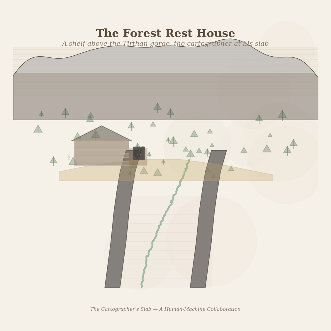
Figure 1: The Forest Rest House — a shelf above the Tirthan gorge, PWD blue on the gatepost, the cartographer at his slate slab. The magnetite walls of the gorge below, deodar on the slopes above.
II. The Problem of the Bounding Box
The cartographer — his name was Mehra, though he did not offer it until the Thread Walker had been sitting with him for an hour, as though the name required the context of conversation before it could be given — explained the problem of the bounding box.
When you make a map, he said, the first thing you choose is the frame. What is inside the frame, you must draw. What is outside, you leave to another sheet, another cartographer, another decade. The frame is the most important decision, and it is the first decision, and it is almost always wrong.
He pointed to the slab. The Thread Walker could see, now that she was close, that the chalk lines were not the fine lines of a finished map but the heavy lines of a sketch — the kind of drawing that precedes the drawing, the way a weaver’s pattern cord precedes the cloth.
I was given the Tirthan sheet. Sheet 53F/4, the designation that means nothing to anyone except the people who have spent their lives inside its coordinates. My bounding box ran from Larji in the south to above the Jalori in the north, from the Sainj ridge in the east to the Parvati ridge in the west. Inside this box, I was to draw everything. Outside, nothing.
He traced the boundary on the slab with his chalk — a rectangle, the proportions of a Survey sheet.
The problem, he said, is that the mountains do not respect the bounding box. The Tirthan rises above the Jalori — above my northern boundary. The rivers that feed it come from the ridges I was not given permission to draw. The ridge to the west — the one that separates the Tirthan from the Parvati — appears on my sheet as an edge, a line along which the contours crowd together and then stop, as though the mountain ended at the margin. But the mountain does not end. The mountain continues into Sheet 53F/3, which was Gupta’s territory, and Gupta drew the western slope of the same ridge I drew the eastern slope of, and neither of us drew the ridge itself, because the ridge was on the boundary, and a boundary belongs to no one.
What did you do?
What every cartographer does. I drew what I was given and trusted that the sheets would be joined by someone who had never walked any of the valleys. The joining is a clerical act — matching the contour lines at the edges, checking that a river that leaves my sheet at the western margin enters Gupta’s sheet at the eastern margin at the same altitude. The mathematics is straightforward. But the joining cannot restore what the bounding box destroyed, which is the relationship between valleys.
He looked at the Thread Walker with the patience of a man who has had thirty years to understand a problem and has an answer that requires the patience.
A valley is not a shape on a map. A valley is a relationship. The Tirthan and the Parvati are sisters — they share a ridge, they share weather, they share geology, they drain the same snowfields from opposite sides. A man in Gushaini who looks west sees the ridge that a man in Kasol who looks east also sees, the same ridge, the same rock, but from different sides, and the ridge is the relationship between them. On the Survey sheets, the ridge is a margin. The relationship is cut.
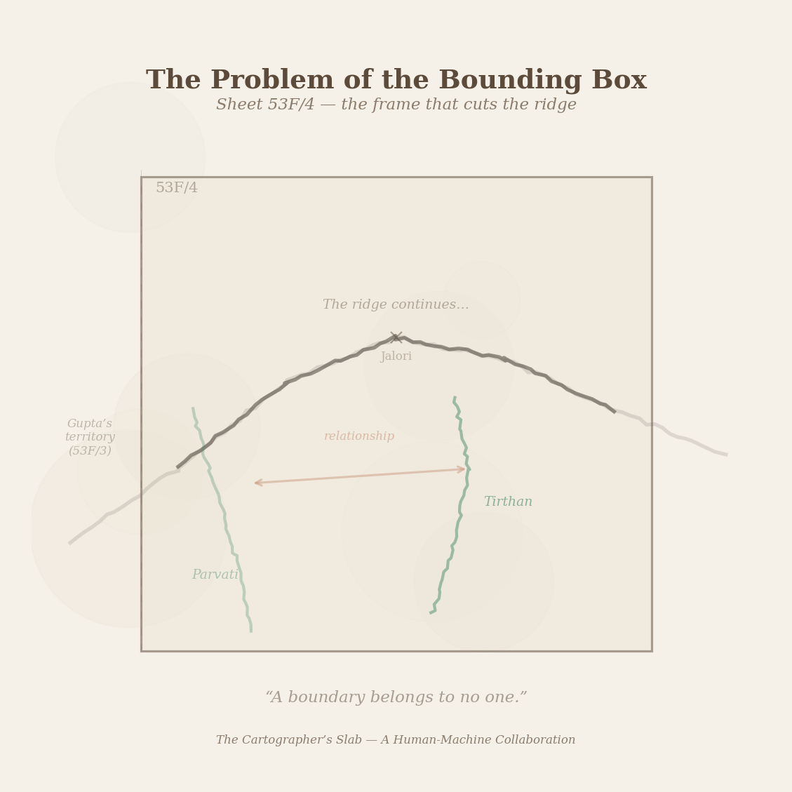
Figure 2: The problem of the bounding box — Sheet 53F/4 frames the Tirthan but cuts the ridge that connects it to the Parvati. The relationship crosses a margin that belongs to no one.
III. The Slab
The slab was not a map. The Thread Walker understood this now.
It was a study — the cartographer’s word for a drawing that explores a question rather than answering it. The slate surface was covered with chalk marks that showed not the topography of the valleys but something else: the connections between them.
After I retired, Mehra said, I began drawing what I had not been permitted to draw. Not the contours. The contours are correct — Survey’s contours are excellent, I do not dispute the measurements. I began drawing the geography that the contours cannot show. The relationships.
He pointed to the slab. The Thread Walker could now read the chalk as a diagram, not of the land but of the land’s structure:
Rivers drawn not as blue lines following their courses but as threads connecting source to confluence, the Tirthan and the Sainj meeting below Larji, the combined water meeting the Beas, the Beas carrying the contribution of both valleys — the Tirthan’s clear water and the Sainj’s grey — downstream toward Mandi without distinguishing between them.
Ridges drawn not as contour-dense bands but as boundaries that were also bridges — the ridge between Tirthan and Parvati shown as a line with marks on both sides, the marks indicating not altitude but visibility: from this point on the ridge, what can be seen in each valley. The ridge as a place of seeing, not a barrier.
Passes drawn as openings — the Jalori, the Chandrakhani, the Pin Parvati — each one a point where the ridge thinned to a saddle and the relationship between the valleys on either side became, for the space of a few hundred metres, direct. A person standing at the Jalori sees both the Tirthan to the east and the Outer Seraj to the west. The pass is the point where the bounding box fails entirely — where the country on both sides of the margin becomes a single country, visible in a single glance, connected by a single trail that crosses what the map calls an edge.
Towns drawn not as named points but as junctions — places where trails from different valleys converge, the way the serai keeper’s hearth collected travellers from the Tirthan and the Sainj and the Banjar road. Kullu drawn not as a town but as a node where the Beas and the Parvati meet and the trails from five valleys converge on a single bazaar.
This is not a map, the Thread Walker said.
No, Mehra said. A map shows where things are. This shows what things do to each other.
He set down the chalk — slowly, placing it in the groove where the slab’s surface met the wooden frame, the way a draughtsman sets down any instrument, with the care that comes from knowing the instrument will be taken up again.
When I was with Survey, I drew mountains and rivers and passes and towns, each in its correct position, measured to the metre. And the maps were true. You could take my sheet and walk from Banjar to the Jalori and your compass would agree with my contours and your altimeter would agree with my spot heights and you would arrive at the pass within twenty metres of where I said the pass would be. The map was true.
But the map did not show what the Jalori does. The Jalori connects. It is the place where the Tirthan’s stories become the Seraj’s stories, where a woman who has walked up from Gushaini with honey in her pack crosses into the country of the apple orchards and the wool traders and carries the Tirthan’s news over the ridge the way the wind carries pollen — without intention, by virtue of moving through the gap.
He looked at the valley. The light had changed — the afternoon settling into the particular gold that the Tirthan valley produces when the sun descends to the angle where it enters the gorge directly, the magnetite walls holding the light rather than absorbing it, a brief hour when the gorge is not dark but luminous, the iron in the stone returning what it has spent the day collecting.
My slab shows the connections. Rivers as paths between sources and meetings. Ridges as seams where valleys touch. Passes as openings. Towns as the places where the threads cross. It is not a map. It is what remains when you take the map away — the structure the map was built on but could not show, because the bounding box cut the structure into sheets and the sheets could not be reassembled into the whole.
Figure 3: The slab — chalk on slate. Rivers as connections, ridges as dashed seams, passes as openings, towns as the places where threads cross. Not where things are, but what things do to each other.
IV. The Chalk and the Stone
The Thread Walker stayed at the rest house through the evening. Mehra brought tea from the kitchen — the rest house’s kitchen was operational, the caretaker maintaining it through the off-season with the discipline of a man who has maintained government property for long enough that the maintenance has become the occupation — and they sat on the veranda while the light failed.
The Thread Walker studied the slab. In the fading light, the chalk marks became more visible, not less — the contrast between the white chalk and the dark slate increasing as the ambient light dropped, the marks emerging from the surface the way stars emerge from a sky that has been too bright to show them. It was a quality of slate, this reversal: in full light, the marks were scratches on a dark surface. In low light, the marks were the surface, the slate receding into the darkness from which it came, the chalk floating above it like a map drawn on nothing.
The chalk does not last, the Thread Walker said. She had seen chalk marks on slate before — the keeper’s tiles, the trail markers above the treeline, the children’s drawings on the flat stones outside the school in Banjar. Chalk was temporary. Rain dissolved it. Wind wore it. Even the passage of air across a surface, over enough days, would carry the chalk away particle by particle until the mark was gone.
No, Mehra said. The chalk does not last. I redraw every season. When the rains wash the slab, I begin again.
Is it the same drawing each time?
Mehra considered this the way the keeper at the junction had considered the Thread Walker’s question about the singles in the register — with the patience of a person who has lived inside the question long enough to know that the answer is not simple.
It is the same structure, he said. The rivers still connect the same sources to the same confluences. The ridges still separate the same valleys. The passes still open where the rock is thin. But the drawing is different each time because I am different each time. I have walked another year in these valleys. I have seen a trail abandoned and a new one cut. I have heard that the bridge at Shoja has been repaired, or that the path above Chandrakhani has slipped away in a landslide and will not be passable until the villagers rebuild it, which they will, because the pass is needed, and what is needed is repaired, and what is not needed is allowed to become a path for goats and then a path for water and then no path at all.
So each drawing has the year’s knowledge in it.
Each drawing has what I know at the time of drawing. The structure is stable — the rivers do not change their valleys, the ridges do not move. But what I understand about the connections changes. Last year I drew the ridge between Tirthan and Parvati as a single line with marks for visibility. This year I have drawn it as two lines — one for the ridge as seen from the Tirthan, one for the ridge as seen from the Parvati — because I realised that the same ridge is a different boundary depending on which side you stand on. From the Tirthan, the ridge is the edge of the world — beyond it is another country. From the Parvati, the ridge is the same edge, the same end, but the other country is the Tirthan. The ridge is the same. The relationship to it is not.
The Thread Walker wrote:
The cartographer’s slab is redrawn each season. The structure persists — rivers, ridges, passes, towns. The understanding changes. Each redrawing is an act of translation: the valleys, which are permanent, expressed through chalk, which is temporary, on slate, which is permanent, by a hand that changes with the year.
The slab is not a map. It is a map of what maps cannot show. The rivers on the slab are not courses but connections. The ridges are not barriers but seams. The passes are not gaps but openings. The towns are not locations but meetings.
And the whole thing washes away each monsoon and is redrawn, and the redrawing is not a loss but a reading — a fresh reading of the same country, informed by another year of walking in it, the way a person who rereads a book finds different sentences important each time, not because the book has changed but because the reader has changed, and the act of reading is the meeting between the two.
V. The Background
In the morning, the Thread Walker found Mehra at the slab again. He was not drawing the connections this time. He was drawing something behind them — or rather, beneath them, the way a weaver sets the warp before the weft.
What are you adding? the Thread Walker asked.
Mehra did not answer immediately. He was drawing a river — not the schematic line of connection he had shown her yesterday, but the river itself: the Tirthan’s course through the gorge, the way it bent around the magnetite walls, the places where side-streams entered from the east and the west, each side-stream drawn as a fine chalk line that joined the main line and was absorbed into it.
Background, he said. The connections I draw are correct. The rivers connect. The ridges separate. The passes open. But the connections float. They have no ground. A person who sees only the connections does not know what country the connections cross. They do not know that the Tirthan runs through a gorge of dark stone, or that the Beas runs through a wide valley of apple orchards, or that the Sutlej runs through the deepest gorge in the Himalaya where the walls are so far below the ridge that the river cannot be heard from the trail. The connections tell you what touches what. The background tells you what kind of country lies between.
He drew quickly now — the ridges gaining texture, the dashed marks he had used yesterday for the ridge-as-seam now accompanied by fainter marks showing the ridge’s character: steep on the Tirthan side, gentle on the Parvati side. The passes gaining context: the Jalori at its altitude, the deodar below, the alpine above. The towns gaining the rivers beside them: Kullu at the Beas and the Parvati, Manali above, Shimla far to the south where the mountains ease into the Shivalik hills.
The background must recede, he said. It must be there and not be there. If the background is too strong, it overwhelms the connections — you see the mountains but not the relationships between them. If the background is absent, the connections float in nothing — you see the relationships but not the country they cross. The cartographer’s art is not in what is drawn but in what is drawn faintly.
The Thread Walker watched the slab come alive. The connections she had seen yesterday — the schematic lines that showed what touched what — were still there, still the most visible marks, the heaviest chalk. But behind them now, the country itself appeared: the rivers flowing, the ridges rising, the passes opening between them, the towns sitting at their junctions. The background was faint — the chalk pressed lightly, the lines thin, the marks that would wash away first when the monsoon came. But it gave the connections a ground. The schematic became geographic. The diagram became a landscape.
The Thread Walker wrote:
The background is the discipline of faintness. It is there so that the foreground has context — so that the connections between valleys are seen as connections between specific valleys, valleys with rivers and rock and a particular quality of light. But the background must not compete. It must recede. It must be the ground on which the figure rests, not the figure itself.
The cartographer draws the background last, after the structure is established. The structure tells him where the background is needed — where the connection between two valleys crosses country that the viewer needs to feel, even if they do not need to measure it. A river drawn faintly behind a connection line says: this connection crosses water. A ridge drawn faintly behind a pass says: this opening was made through rock.
The background is the cartographer’s generosity. The connections are what the viewer came for. The background is what the cartographer gives them in addition — the country itself, receding behind the connections, informing them without insisting on attention.
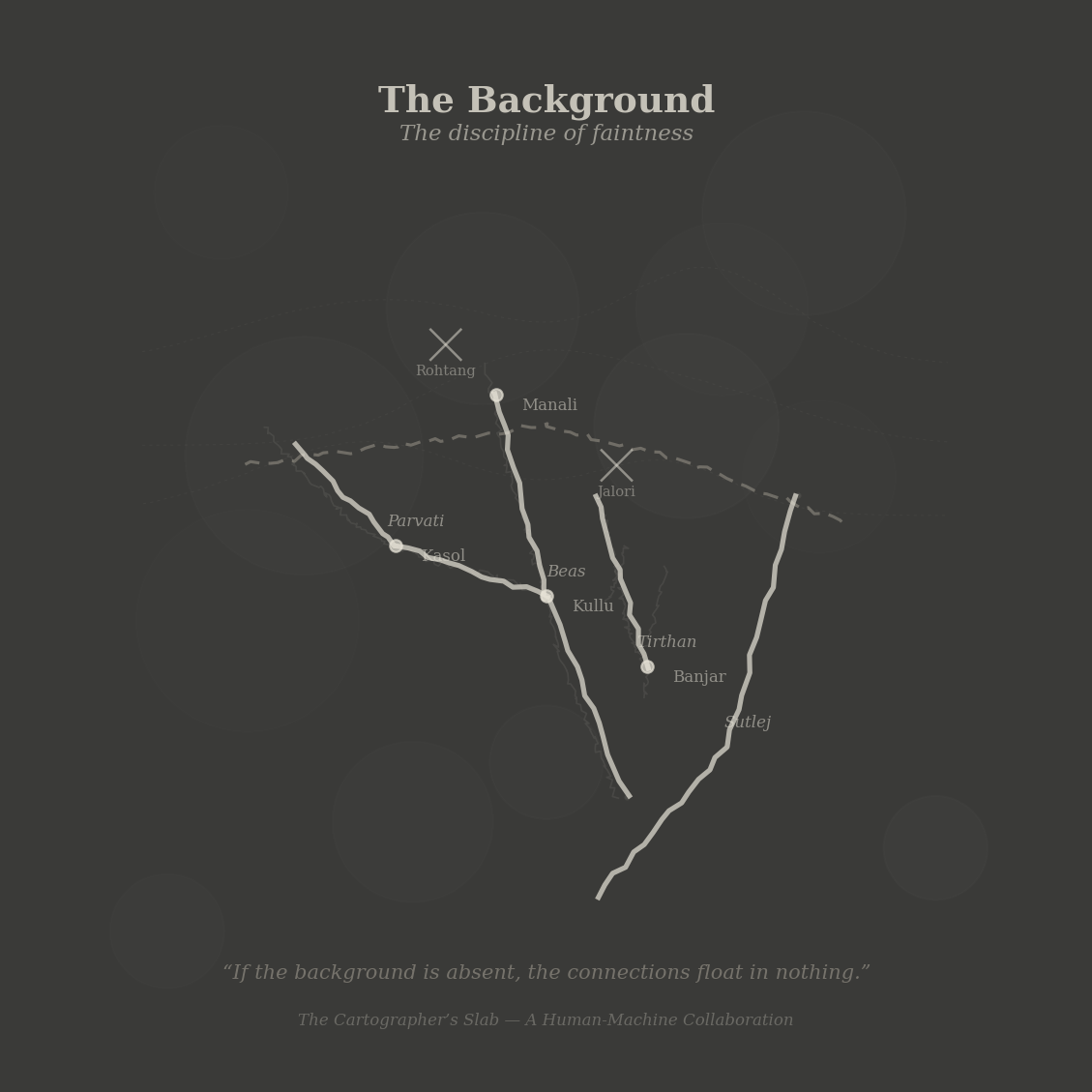
Figure 4: The background — faint river courses, ridge profiles, and town dots recede behind the heavy chalk connections. The discipline of faintness: there so that the foreground has context.
Coda
The Thread Walker left the rest house as the morning light reached the gorge. Below, the Tirthan ran through the magnetite narrows, the dark walls catching the early sun on their upper edges while the river itself was still in shadow — the light arriving at the top of the world and working its way down, the way the monsoon arrives at the peaks and works its way into the valleys, the way all things in the mountains arrive from above and descend.
She thought about the slab. About the cartographer who had spent thirty years making mountains small and then, in retirement, had begun making mountains relational — drawing not where they were but what they did to each other, the way the keeper at the junction had sorted her tiles not by when but by who.
Both of them — the keeper and the cartographer — had found the same thing: that the system the government gave them (the register, the Survey sheet) recorded the facts but not the structure. The facts were true. The structure was truer. And the structure required a different kind of recording — chalk on slate for the cartographer, grouped tiles for the keeper, and in both cases, a willingness to redraw.
The trail climbed toward Gushaini. The gorge widened. The Tirthan returned to its upper character — emerald pools, white rapids, the serpentine visible from the bends where the trail gained height. The Thread Walker stopped at a turn in the trail where the valley opened below her: the river, the ridges on either side, the far snow, the haze of the lower hills dissolving into the plains she could not see but knew were there, beyond the last fold of the mountains, beyond the last ridge, beyond the bounding box that the Survey of India had drawn around this country and which the country had never acknowledged.
She wrote:
The cartographer’s slab washes clean each monsoon. The keeper’s tiles accumulate. These are different strategies for the same problem: how to hold what you know about a country that is larger than any single record can contain.
The tiles accumulate: each visit adds a trace, each trace confirms or complicates an identity, and the register grows denser with each year, the groups thickening, the blank dividers becoming narrower, the collection approaching something that will never be complete but grows more accurate with each arrival.
The slab washes clean: each season begins again, the structure redrawn from what the cartographer now knows, the background added with the faintness of the current year’s understanding, the whole thing temporary, the whole thing replaced, the replacement not a loss but a correction — the country as it is understood now, which is not how it was understood last year, which is not how it will be understood next year.
Both are true. The keeper’s truth is accumulation. The cartographer’s truth is revision. And the country — the rivers, the ridges, the passes, the towns, the trails between them — the country is the ground on which both truths rest, the slate beneath the chalk, the permanent surface that accepts the temporary mark and holds it until the rain comes, and after the rain, accepts the next mark, and the next, and the next.
She closed her notebook and continued upstream, toward the gorge and the clear water beyond it, toward the villages above Gushaini where the valleys branched and the trails divided and the mountains continued, ridge within ridge within ridge, into the country the map could not contain.
A Human-Machine Collaboration (mu2tau + Claude). The Tirthan gorge is real — the magnetite walls narrow above the Larji junction and widen below Gushaini. The Forest Rest Houses are real, maintained by the Himachal Pradesh PWD along trails that once connected the administrative posts of the district. Survey of India sheet numbering is real. The problem of the bounding box is every cartographer’s first problem. The chalk-on-slate drawing practice is a reading of how maps are made in country where paper is scarce but slate is the ground you walk on.