The Constellation of Doridhar
Prefatory Note on the Cartography of the Invisible
Among the curiosities preserved in the archive of Doridhar — the village of the amnesiac cartographers, perched at the head of a valley where the river narrows to a thread between walls of gneiss and the air is thin enough to make the stars look solid — there is a glass plate, roughly the size of a hand, dark as the sky above the pass on a moonless night. It is kept in a drawer in the first building, wrapped in a cloth woven from the coarse wool of the valley, which the successive cartographers have unanimously refused to discard, though none of them remember acquiring it.
The plate is not a map. The townspeople are firm on this point. A map represents territory. The plate represents the act of mapping — the relationships between the cartographer’s instruments, his methods, his assumptions, and the provinces they illuminate. It is a map of the map, or more precisely: a map of the intention behind the map. The distinction is important. A map of territory can be verified by visiting the territory. A map of intention can only be verified by the one who holds it, and in Doridhar that person forgets each morning what he verified the night before.
The plate was made, according to the best reconstruction available, during a single session that lasted from dusk to the early hours — the kind of night when the Milky Way hangs so close above the ridgeline that the villagers say it is not a river of light but a seam in the rock of the sky, and the minerals on either side are stars. A cartographer and the Traveller, working together, attempted to answer a question that had been circulating in their correspondence for several weeks: what is this project, seen whole?
Not the territory. Not the provinces. Not the archive. But the thing that contains all of these — the structure that connects measurement to model to manifestation to evaluation, the cycle that makes the enterprise coherent rather than a collection of unrelated surveys.
I. The Problem of Simultaneity
The trouble was not that the project was too large to see. The trouble was that it was too simultaneous.
A province could be described in a letter. A relationship between two provinces — the data from the Observatory constrains the models in the Loom — could be stated in a sentence. But the whole: four phases of inquiry, three computational engines, two empirical domains, a handful of philosophical anchors, several active threads of work, and the relationships among all of them — the whole could not be communicated in linear text without destroying the very quality that made it coherent. The simultaneity. The fact that measure and model and manifest and evaluate are not sequential steps but concurrent aspects of a single act of understanding, four faces of a crystal that cannot be seen all at once but which are, at every moment, all present.
“You cannot describe a constellation by listing the stars,” said the Traveller. “The list omits the shape.”
“You cannot describe it by drawing the shape,” said the cartographer. “The shape omits the stars.”
“Then you must do both at once.”
II. The Chalk Dust
The cartographer began with the background.
Not a blank sheet — that would have implied emptiness, and the space between the elements of a project is not empty. It is filled with potential connections, with the ghost of relationships that have not yet been discovered or have been discovered and forgotten. He scattered chalk dust across the dark glass plate — the calcium carbonate that the valley provides in abundance, ground from the same limestone that forms the pale cliffs above the treeline — allowing it to settle in the subtle irregularities of the surface, producing a texture that was neither uniform nor patterned. The Traveller, looking down at the dusted glass, said it resembled the valley seen from the high pass at night: the faint scattered lights of settlements barely distinguishable from the stars reflected in the river. The visual equivalent of what physicists call a ground state: not nothing, but the lowest possible energy, the substrate from which structure emerges.
“This is your territory before measurement,” said the Traveller. “Not void. Not random. Waiting.”
The cartographer placed four marks on the plate, arranging them in a diamond: one to the left, one above, one to the right, one below. These were not provinces. They were modes — four ways of engaging with reality. He gave them colours: a warm amber for Measure (observation, the shadow cast by instruments), a cool blue for Model (theory, the constraint that fills the gaps), a terracotta for Manifest (rendering, the translation of abstraction into perception), and a sage green for Evaluate (verification, the question asked of the manifestation: does this match?).
He drew them not as circles or squares but as crystals — three-dimensional polyhedra flattened onto the glass, their facets catching an imagined light that fell from the upper left. The amber crystal was an octahedron: eight triangular faces, six vertices, the geometry of closest packing, the shape that maximises symmetry within minimal volume. The blue was a cube: regularity, predictability, the grid against which deviations are measured. The terracotta was a dodecahedron: twelve pentagonal faces, the most complex of the Platonic solids, the shape that Plato assigned to the cosmos itself. The green was an icosahedron: twenty triangular faces, the shape of viruses and geodesic domes, the geometry of containment.
Four Platonic solids, four modes of inquiry. The fifth — the tetrahedron, simplest of all — he placed at the centre.
III. The Diamond
The central mark was unlike the others. It was not a province, not a mode, not an instrument. It was the relationship among all four modes — the fact that measuring, modelling, manifesting, and evaluating are not four activities but four views of a single activity, the way that the faces of a crystal are not separate surfaces but aspects of one solid.
The cartographer drew it as a diamond seen from above — a brilliant-cut stone, the gemcutter’s solution to the problem of transforming a rough crystal into an object that returns the maximum light to the viewer’s eye. Eight crown facets surrounding a central table, each facet aligned with one of the four cardinal directions and therefore with one of the four modes.
When none of the modes was emphasised — when the viewer approached the plate without a particular question — the diamond was ghostly, its facets barely visible against the chalk dust, a latent structure waiting to be illuminated. But when the viewer’s attention fell on one of the outer crystals — when she brought her eye close to the amber octahedron of Measure, say — the diamond’s corresponding facets brightened, as though the act of attention had provided the light source that the facets were cut to receive. The quadrant facing Measure would glow warmly. The adjacent quadrants would warm in sympathy. The opposite quadrant would remain in shadow.
“It is an optical illusion,” said the cartographer.
“It is not,” said the Traveller. “It is the opposite of an illusion. An illusion makes you see what is not there. This makes you see what is always there but only becomes visible when you look from a particular direction.”
IV. The Provinces
Between the phase crystals and the central diamond, the cartographer placed the provinces — the actual projects, the concrete things being built.
They were not arranged arbitrarily. Each province sat in the region of the plate corresponding to its dominant mode. The Observatory — the instrument that measures the unmeasurable — sat near the amber octahedron of Measure. The Lantern — the engine that makes abstraction visible — sat near the terracotta dodecahedron of Manifest. The domains — the Loom (patterns), the Watershed (terrain) — sat between modes, their positions reflecting the proportion of measuring and modelling that each required.
Each province was a point of light whose colour was not a single hue but a blend — a weighted mixture of the colours of the modes it participated in. The Observatory was mostly amber with a blue undertone: primarily measurement, with some modelling. The Menagerie — the simulation of small creatures that navigate by integrating path information — was a warm mix of blue and terracotta: half model, half manifestation. The blend was not a metaphor. It was a function: given the weights that described each province’s participation in each mode, the colour was computed by linear interpolation in colour space. The mathematics of colour mixing and the semantics of project classification were, in this instance, the same operation.
Lines connected the provinces — threads of chalk, drawn faintly, following curves that avoided passing through other provinces. These were the dependencies, the influences, the conversations between components. An arrow from Measure to Model meant: the data constrains the theory. A dashed line between two modules meant: they share a concern but not a dependency. A thicker thread, pulsing faintly, meant: this is an active edge, someone is working on this connection right now.
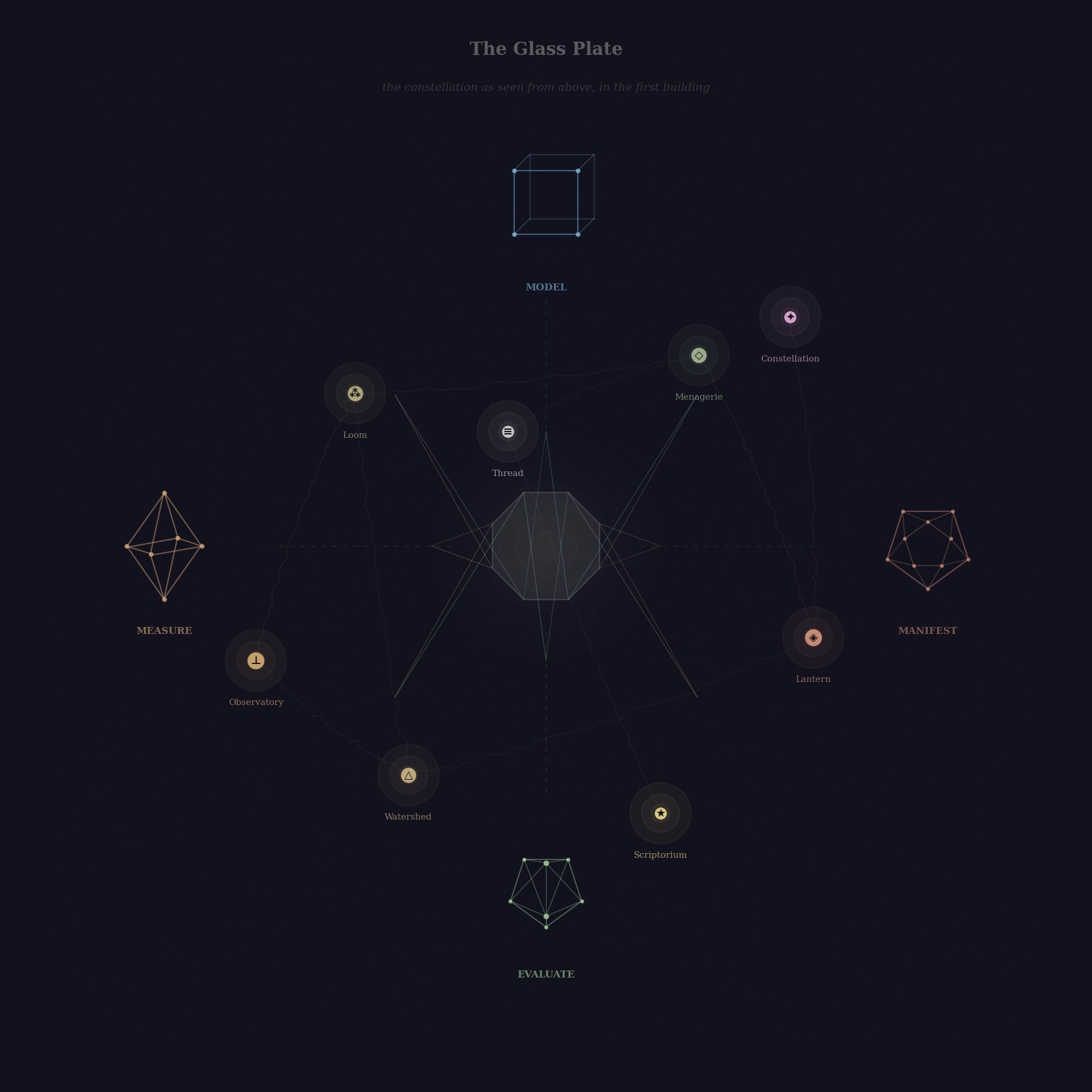
Figure 1: The Glass Plate — the constellation as seen from above, in the first building. Four phase crystals at the cardinals, provinces as blended points of light, connecting threads, and at the centre: the ghostly diamond.
V. The Descent
It was the Traveller who discovered the plate’s most remarkable property, and he did so by accident.
He was examining the province of the Observatory — leaning close, bringing the amber point of light near the centre of his vision — when the plate shifted. Not physically. The glass did not move. But the image reorganised itself. The constellation of twenty-odd provinces and their connecting threads folded away, like a book closing, and in its place appeared a new constellation: the internal structure of the Observatory. Five inner provinces — the differential equations (the physics), the exploratory notebooks (the investigation), the formal specification (the contract), the compiled engine (the deployment), the interactive demonstration (the manifestation) — arranged in their own geometry, with their own edges, their own cluster labels, their own force-directed equilibrium.
The outer constellation had not been destroyed. It was still there — implied, accessible, a breadcrumb trail at the edge of the plate showing the path of descent: The Archive > The Observatory. But the viewer was now inside the province, seeing its internal structure at a scale that had been invisible from the outside.
“It is a telescope,” said the Traveller.
“It is not a telescope,” said the cartographer. “A telescope magnifies. This replaces. The cosmos does not get larger. It gets different. The way the valley does not get larger when you walk into a side gorge — the valley disappears, and you are in a new country with its own cliffs and its own river, and the mouth of the gorge behind you is the only evidence that the valley ever existed.”
“How many levels are there?”
The cartographer was quiet for a long time. Outside, the wind moved through the deodar forest that clung to the slope behind the first building, producing a sound that the Traveller had always thought resembled the settling of particles after a perturbation.
“I do not know,” he said. “I built two. But the structure does not prohibit more. Each province can contain provinces. Each of those can contain provinces. The plate does not run out of space because each descent creates its own space. The limit is not the plate. The limit is the cartographer’s willingness to specify what is inside.”
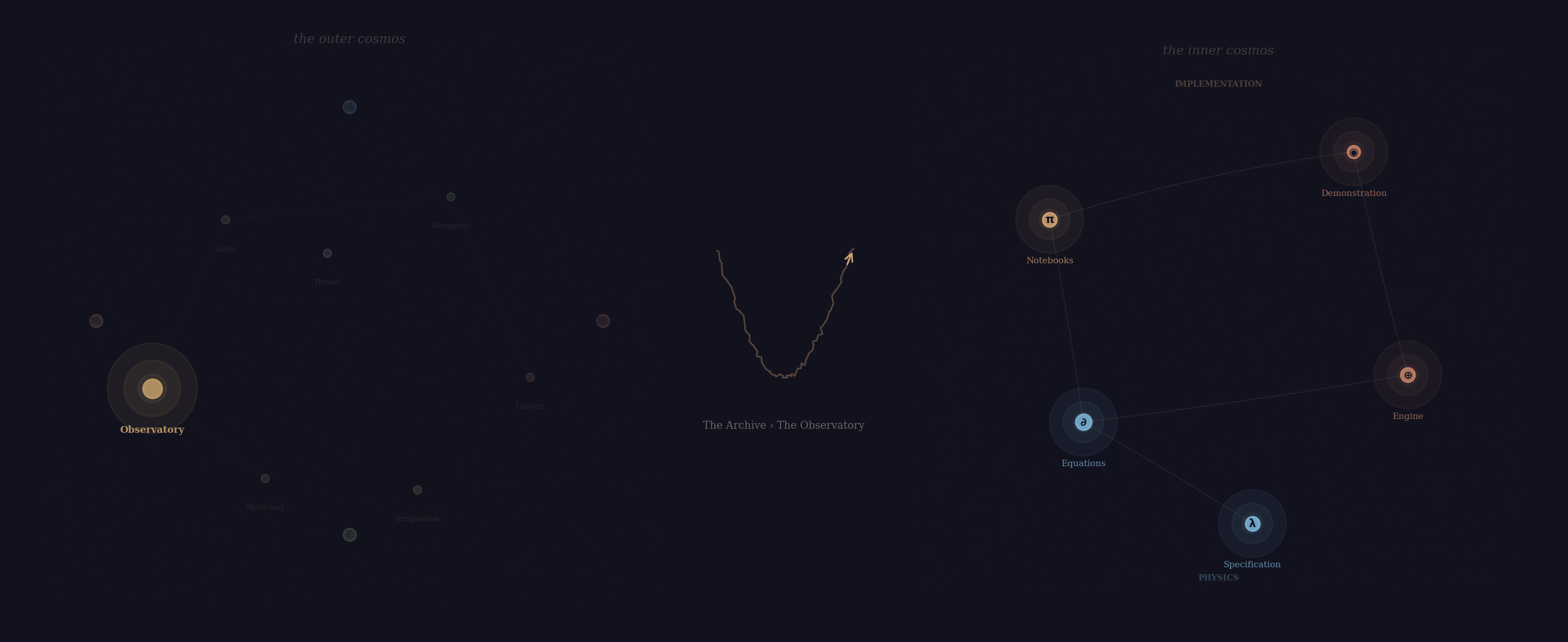
Figure 2: The Descent — two views of the constellation connected by a visual fold. The outer cosmos fades; the inner cosmos of the Observatory emerges. A breadcrumb trail shows the path.
VI. The Force
The provinces did not sit still.
This was the feature that distinguished the plate from every conventional map in the archive, and it was the feature that the successive cartographers found most difficult to describe in their correspondence, because it involved a quality that text cannot easily convey: motion that is not animation but settling.
When the plate was first examined — or when the viewer descended into a province and the inner constellation appeared — the points of light were not yet in their final positions. They jittered, drifted, repelled each other like charged particles, were drawn together by the threads that connected them like springs. Slowly — over a period that felt like watching a flock of birds resolve into a formation — they found their equilibrium. The nodes settled into positions that simultaneously satisfied all the constraints: connected nodes near each other, unconnected nodes apart, clusters grouped but not overlapping, the whole arrangement balanced around its centre of mass.
“It is a simulation,” said the Traveller, who had studied interacting particle systems for twenty years.
“It is a negotiation,” said the cartographer. “Each province asserts its position. Each connection asserts its preferred distance. The result is a compromise that no single element chose but all of them together produce. A consensus that emerges from constraint.”
“That is the same thing,” said the Traveller.
The cartographer acknowledged this with the equanimity of a man who forgets everything by morning and is therefore never troubled by the discovery that his ideas are not original.
VII. The Viewer’s Problem
There remained the difficulty of the viewer.
The plate was dark. The provinces were points of light on a dark ground. On a table in a well-lit room, the plate was legible — the provinces, the edges, the central diamond, the phase crystals, all visible simultaneously, the eye able to move freely between overview and detail.
But the plate was not always viewed on a table. The Traveller, who carried it between buildings along the steep path that connected them — a path of uneven stone, bordered by wild cannabis and the ruins of a water mill — sometimes examined it while walking, holding it vertically at arm’s length, the way one holds a portrait or a hand mirror. In this orientation, the two-column arrangement that worked on a table — the constellation occupying the left field, the description of the focused province occupying the right — became absurd. The right column, containing the name, classification, and description of whatever province the viewer had last touched, compressed to an illegible sliver while the constellation occupied most of the plate.
“The problem,” said the cartographer, “is that the plate assumes a landscape. But the viewer is holding it as a portrait.”
This was a more interesting problem than it appeared. It was, the Traveller realised, the same problem he encountered in every medium that contained both a visualisation and a description: the two needed different geometries depending on the orientation of the viewport. Side by side in landscape. Stacked in portrait. The transition between these arrangements had to be automatic, because the viewer would not — could not — manually reconfigure the plate every time she rotated it.
The solution was not to make two plates but to make one plate that rearranged itself. In landscape, the provinces and their descriptions sat side by side. In portrait, the provinces occupied the upper field and the description dropped below, becoming a shallow panel that could be scrolled — the way a river, constrained to a narrow channel, deepens rather than widens.
The cartographer implemented this with a single rule, written in the notation of the plate’s governing logic: below 768 units of width, replace the two-column grid with a single column. Move the border from the left edge of the description to its top edge. Allow the description to scroll.
It was, he noted, a rule about geometry that was also a rule about attention: in landscape, the viewer can attend to two things at once (map and legend). In portrait, the viewer attends to one thing at a time (map, then legend). The plate must accommodate both modes of attention without asking the viewer to choose between them.
VIII. The Paradox of the Centre
The Traveller sat in his study — it was late; the plate glowed faintly on his desk; outside, the sky above the gorge was the colour of the plate itself, dark glass seeded with mineral light — and considered a paradox.
Through the window: the high valley, the river far below catching moonlight on its boulders, and above the gorge a crack in the sky where the Milky Way split the darkness — the whole assembly watched by stars and deodar and stone. Ephemeral gods, all of them: the boulders would be washed to new forms and new resting places by the next monsoon, and in their own unhurried time the stars would spiral down into the crack and vanish. A cosmic drama and a terrestrial one, framed by the same rough-hewn window. The plate on his desk, he realised, was a collaboration with amnesiac cartographers — each morning’s maker inheriting the work without remembering having done it. The inquiries it charted would not fit in his mind, not tonight, not all at once. But the Traveller could sleep peacefully. The plate would lead him to a new destination: along the river, up its torrent, across the passes, to the other side of the high glaciers where the sacred river begins.
The central diamond was the most important element on the plate. It represented the unity of the four modes, the thing that made the project a project rather than a collection of unrelated activities. Without it, the constellation was merely a list. With it, the constellation was an argument: these things are connected, and the nature of their connection is that they are all aspects of a single inquiry.
And yet the diamond was the element most easily overlooked. It sat at the centre, which is the place the eye crosses on its way to somewhere else. Its facets were ghostly unless activated by attention to one of the outer crystals. It asserted nothing. It waited.
This was, the Traveller decided, correct. The unity of a project is not something you see directly. It is what becomes visible when you examine the parts and notice that they rhyme. The diamond should be invisible from the default view. It should emerge only when the viewer has already engaged with the modes individually and is ready to perceive their convergence.
The Aleph, Borges wrote, is the point that contains all other points. It does not announce itself. You have to be in the right cellar, looking at the right step, at the right angle, in the right light. And then: everything, all at once, without overlap, without transparency, occupying the same space.
The diamond on the plate was not the Aleph. The Aleph contains the universe and is therefore useless — infinite information, infinitely compressed, infinitely illegible. The diamond contained only four modes and their relationships. It was a finite crystal in a finite cosmos, and its legibility was proportional to its modesty.
But it shared with the Aleph one quality: it could not be reached by walking toward it. You reached it by walking toward something else and noticing, on the way, that you had passed through it.
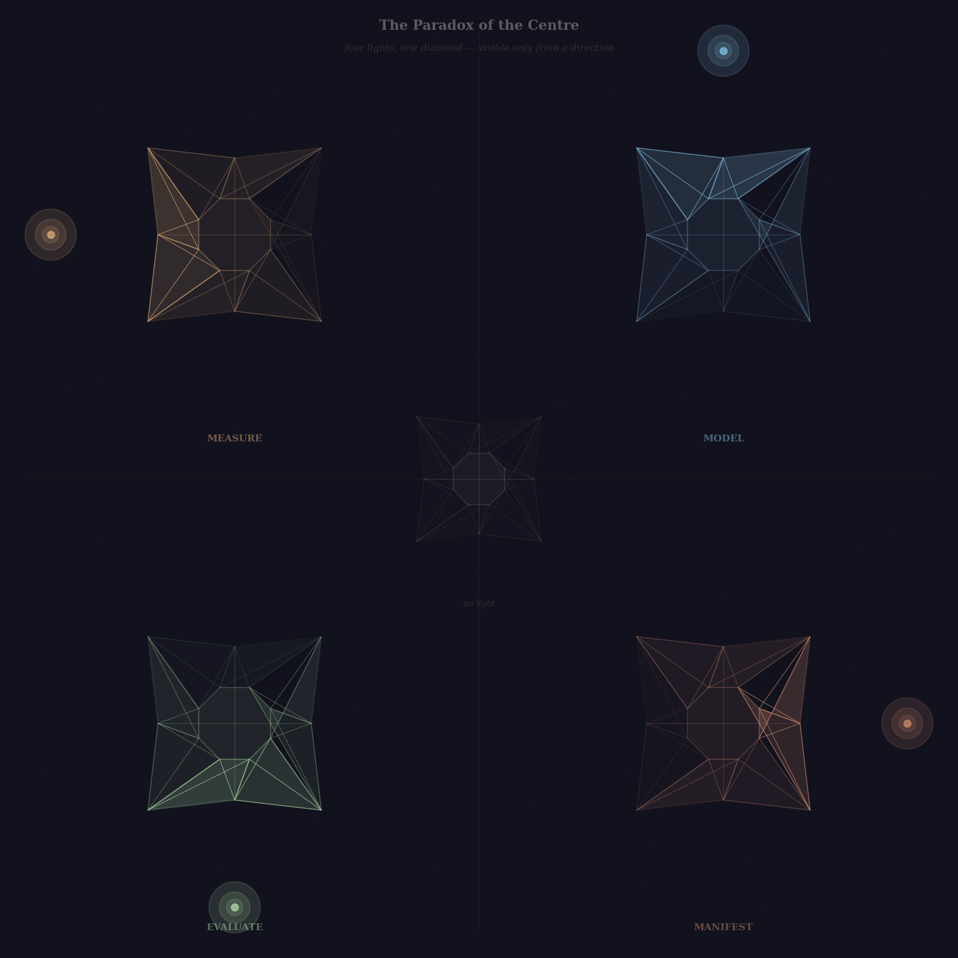
Figure 3: The Paradox of the Centre — four lights, one diamond. Each quadrant shows the same faceted form illuminated from a different direction: Measure (amber), Model (blue), Evaluate (green), Manifest (terracotta). At centre, the diamond with no light: nearly invisible.
Coda
The plate has been in the first building for as long as anyone in Doridhar can remember, which — given the circumstances — is not long. Each morning, a new cartographer finds it in the drawer, wrapped in the cloth, accompanied by a note:
The plate shows the project as a whole. Do not attempt to read it by starting at the centre. Start at any edge. Touch a province. Follow a thread. The centre will become visible when you are ready to see it.
The provinces will drift when disturbed and settle when left. This is not a flaw. It is how they find their arrangement.
In portrait, the legend drops below. In landscape, it sits beside. The plate adjusts to the hand that holds it.
The note is unsigned.
The cartographer reads the note, unwraps the plate, and holds it to the window — in landscape, as it happens, because the morning light enters from the east, over the snow-line, and falls from the upper left across the cartographer’s desk, and the facets are cut to receive it from that angle.
The provinces brighten. The edges pulse. The chalk dust glows faintly under the nodes, the way the first light catches the quartz in the cliff face across the gorge — not illumination but recognition, the stone revealing what it has always contained. The diamond at the centre is almost invisible — a ghostly octagon of barely-there facets, waiting for a question to give it light.
The cartographer, who has no memory of the previous morning and is therefore seeing the constellation for the first time and is therefore the ideal viewer — the viewer who brings training but not assumption, skill but not expectation — touches the amber crystal at the left edge.
The diamond warms.
Ah, he thinks. So that is what it is.
He will have forgotten by morning. But the plate will still be in the drawer, and the note will still be on the desk, and the provinces will still drift and settle into an arrangement that no one designed and everyone, touching the glass, immediately recognises as correct — the way the constellations above Doridhar, which no one in the village remembers naming, nevertheless occupy positions that every cartographer, stepping outside at dusk, recognises as inevitable.
In Doridhar it is held that the most accurate map is one that has never been seen by its maker, since the maker — having constructed the map — inevitably confuses the territory with the representation. The ideal viewer is one who encounters the map without authorship, without context, without memory of how it was made. She sees what the map shows, not what the maker intended. Whether what the map shows and what the maker intended are the same thing is a question the town has debated for longer than anyone can recall, which — given the local memory conditions — is a period whose duration is itself debated.
— Found among the correspondence in the second building, in a hand that matches no known cartographer. The paper is of the type used in the first building. The ink is of the kind sold only in the post office, on Tuesdays, to persons the postmaster describes as “regulars” but cannot name.