Prefatory Note on Contours
A contour line connects points of equal elevation. It was invented — or discovered, depending on one’s philosophy of cartography — by the Dutch surveyor Nicolaas Cruquius in 1728, who drew lines of equal depth on the bed of the river Merwede. Before Cruquius, elevation was indicated by hachures — short strokes drawn in the direction of steepest descent, thicker where the slope was steeper. Hachures showed the shape of the land the way a woodcut shows a face: by impression, by the accumulation of marks that suggest but do not measure.
The contour replaced the hachure the way the thermometer replaced the hand on the forehead. Both convey temperature. One of them can be argued with.
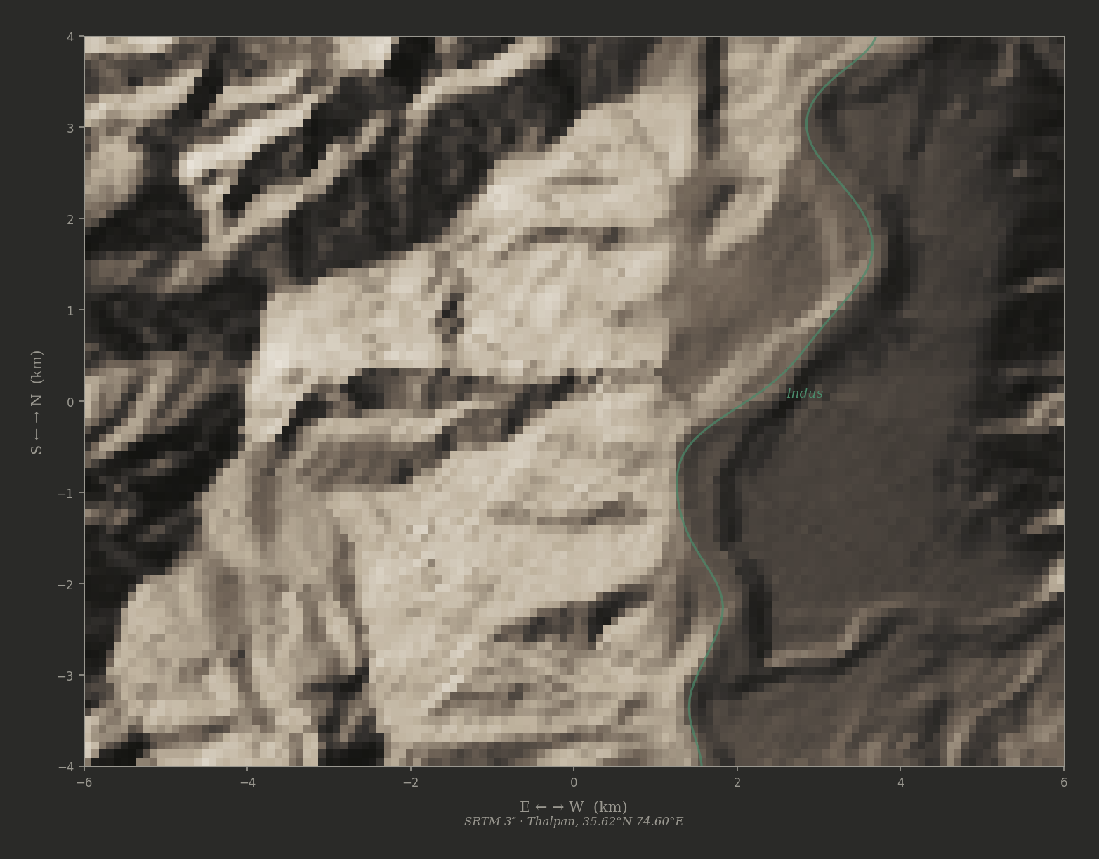
In the gorges of the upper Indus, where the river drops three hundred metres in forty kilometres and the walls rise three thousand metres in five, the contour lines on a survey map crowd together until they merge into a solid band of ink. The map becomes unintelligible at precisely the places where precision matters most. The gorge defeats the notation that was invented to describe it.
What follows is from the Thread Walker’s notebooks, written during two days on the terraces above Thalpan, in the company of a woman who made pictures from measurements.
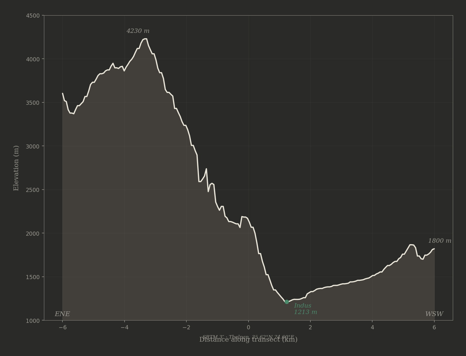
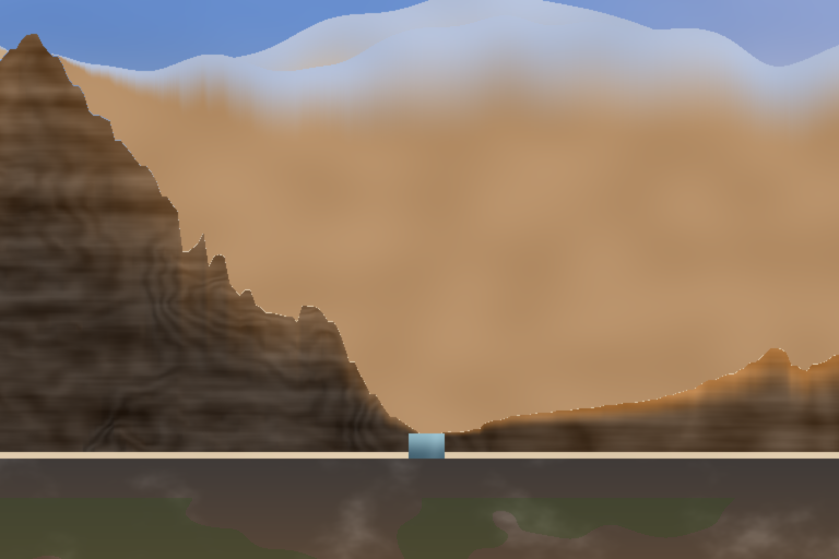
The SRTM transect through Thalpan, ENE to WSW. The eastern wall climbs three thousand metres in five kilometres. The western wall climbs six hundred. The gorge is not a cut — it is a wound.
I. The Asymmetry
The Thread Walker noticed it on the first morning, before anyone told her what she was seeing. The gorge was not symmetrical. The wall to the east-northeast rose in a single sustained cliff — dark rock, nearly vertical, climbing from the river at twelve hundred metres to a ridge at four thousand three hundred in less than five kilometres. The wall to the west-southwest was gentler, paler, reaching only eighteen hundred metres before levelling into a series of terraces and benches that stepped upward toward ridges she could not see.
She wrote:
The eastern wall climbs three thousand metres in five kilometres. The western wall climbs six hundred. The gorge is not a cut — it is a wound, and the wound is not symmetrical because the two bodies it separates are not the same body.
She had been at the terraces for two days already — the petroglyphs, the marks, the ten writing systems. But the petroglyphs sat on flat boulders at river level. They said nothing about the shape of the space they occupied. Ten thousand years of carving, and not one mark recorded the profile of the gorge itself — its height, its asymmetry, the fact that one wall was made of Kohistan arc basalt and the other of Indian plate gneiss and that the difference between them was not cosmetic but continental.
The carvings were a record of passage. The gorge was a record of collision. Neither recorded the other.
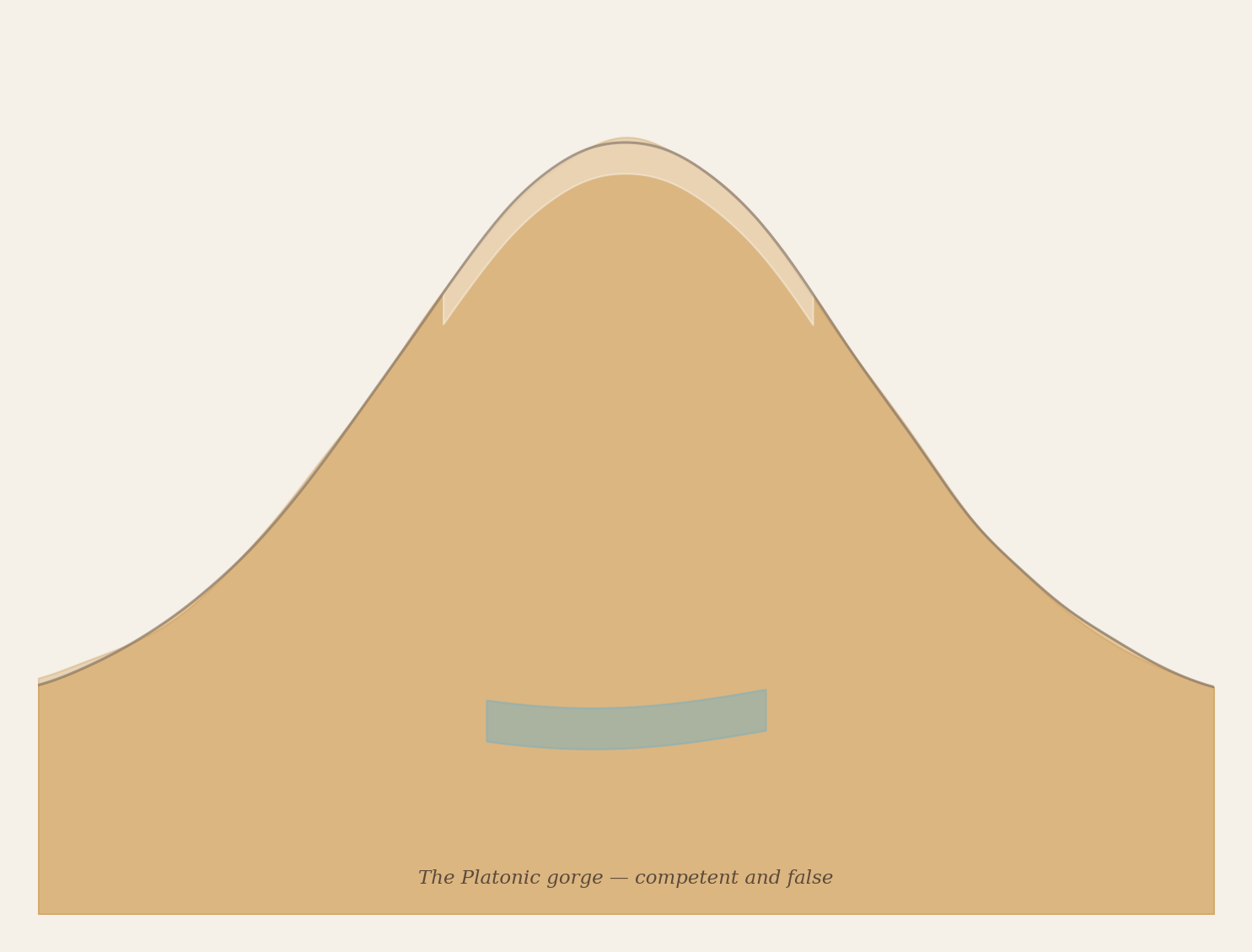
The Platonic gorge — symmetrical, golden, and wrong. The average of ten thousand gorges is not a gorge.
II. The Painter
On the third morning, the Thread Walker met the woman on the terrace above the river. She was sitting cross-legged on a flat rock with a metal case open beside her, and inside the case were not brushes or pigments but a computing machine of some kind — flat, warm, humming faintly. A cable ran from the machine to a device that the Thread Walker did not recognise: a box the size of a book, with no visible controls, which sat on the rock and did nothing.
I am making a picture of the gorge, the woman said, without looking up.
The Thread Walker sat beside her. On the machine’s screen was an image — not a photograph, not a painting, but something between the two. It showed a gorge with steep walls, a river at the bottom, snow peaks in the distance. The light was warm, golden, the kind of light that exists for twenty minutes at dawn in the months when the sun clears the eastern ridge early enough to strike the western wall before the haze rises.
It is beautiful, the Thread Walker said.
It is wrong, the woman said.
She turned the screen so the Thread Walker could see it fully. Look at the walls. Both the same height. Both the same slope. The gorge is symmetrical. But this gorge — she gestured at the space around them, the dark wall rising to the east, the pale terraces stepping down to the west — this gorge is the most asymmetric valley on earth. The eastern wall is three times the height of the western. The rock is different. The slope is different. The drainage is different. Everything is different. The picture shows a gorge. It does not show this gorge.
She tapped the screen. A new image appeared — similar composition, different light, different arrangement of snow on the peaks. Also symmetrical. Also wrong.
I asked it for the Indus gorge at Thalpan, she said. I gave it the names. I gave it the geology. I described the asymmetry in words. But the machine that makes pictures has seen ten thousand gorges in its training, and most gorges are roughly symmetrical, and so it makes a symmetrical gorge and calls it Thalpan. The name is a label. The picture is an average.
She closed the images. The average of ten thousand gorges is not a gorge. It is a concept of a gorge — a gorge that exists nowhere but satisfies the idea of gorge-ness well enough that someone who has never been to a gorge would accept it.
The Thread Walker wrote:
The painter’s machine has seen many gorges and remembers none of them. It has learned what gorges look like in general and has forgotten what any particular gorge looks like. When asked for Thalpan, it produces the Platonic gorge — the gorge-in-itself, stripped of everything that makes Thalpan Thalpan. The asymmetry is the first casualty. The rock type is the second. The light — which at Thalpan falls from the east-northeast and strikes the western wall while leaving the eastern in shadow at dawn — is the third.
The picture is competent and false.
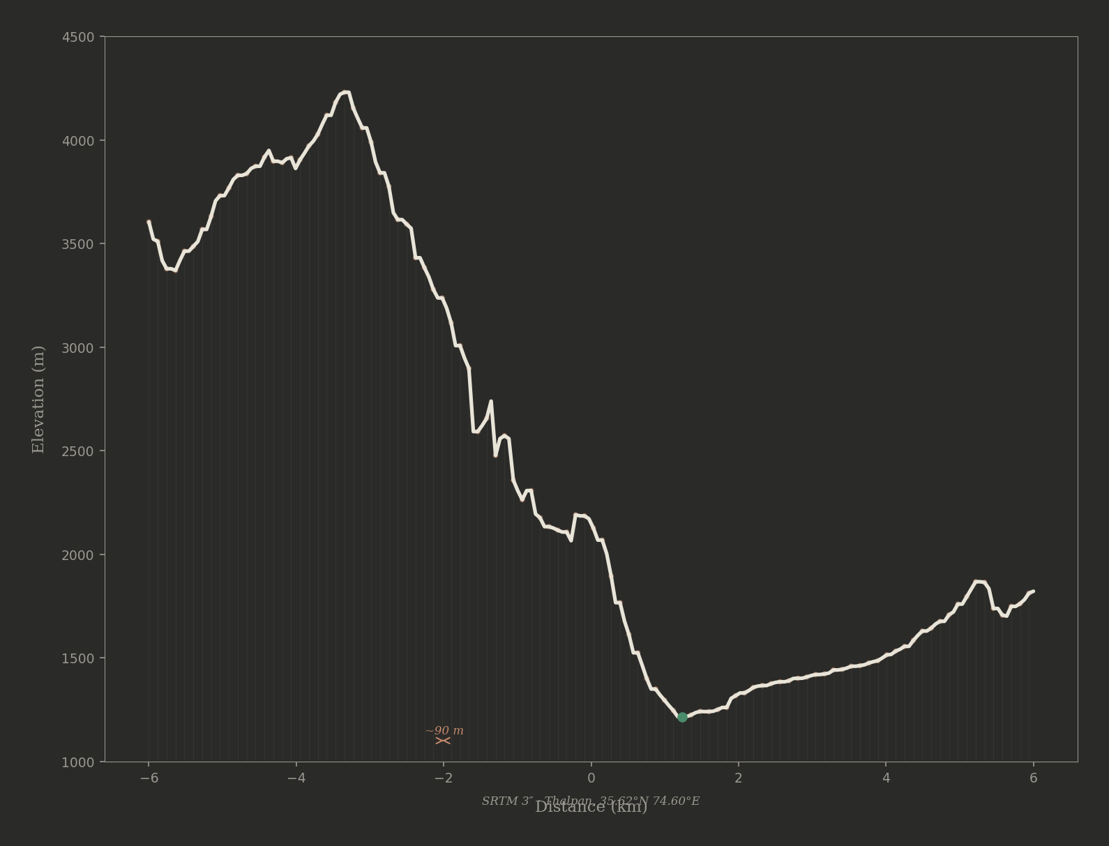
Two hundred measurements, ninety metres apart. The numbers do not lie, and the numbers do not average.
III. The Survey
The woman opened a different file on her machine. This one was not an image but a column of numbers — two columns, in fact. Distance and elevation. Hundreds of rows.
This is the shape of the gorge, she said. Not a picture of the shape. The shape itself. Measured.
How?
From above. A satellite passes over this valley and measures the height of the ground at intervals of ninety metres. Three arc-seconds of latitude. Roughly the length of a football pitch. At each point, it records the elevation above the sea to the nearest metre.
She traced her finger down the columns. Here — the river. Twelve hundred and thirteen metres. And here — her finger moved to the right — five kilometres to the east-northeast, four thousand three hundred metres. And here — back to the left — five kilometres to the west-southwest, eighteen hundred metres. The asymmetry is in the numbers. The numbers do not lie, and the numbers do not average. They describe this gorge, this valley, this collision — not the concept of a gorge but the fact of one.
She pressed a key. The numbers became a line — a profile, drawn from left to right across the screen. The Thread Walker saw it immediately: the deep V of the river at the bottom, the sheer wall rising on the left, the gentle slope on the right. The profile was not beautiful. It was not composed. It had the ungainly honesty of a thing that had been measured rather than imagined.
That is the cross-section, the woman said. East-northeast to west-southwest, through the terrace where you have been reading the petroglyphs. The satellite does not know about the petroglyphs. It does not know about the writing systems or the ibex or the dam. It knows only the height of the ground. But the height of the ground contains the whole story — the collision, the uplift, the differential erosion, the reason one wall is basalt and the other gneiss, the reason the river is here and not somewhere else.
The Thread Walker looked at the profile. The eastern wall — the Kohistan arc, the oceanic crust caught between continents fifty million years ago — rose in a line so steep it was nearly a cliff on the screen. The western wall — the Indian plate, the old continent, the gneiss that had been gneiss since the Proterozoic — sloped gently, terraced, stepped. The asymmetry was not subtle. It was the dominant feature. Any picture of this gorge that did not show it was a picture of a different gorge.
She wrote:
The satellite does not compose. It does not choose a viewpoint or a time of day or a colour palette. It passes overhead at its appointed time and measures what is below. The measurement is crude — ninety metres between points, one metre of vertical resolution. A climber on the eastern wall could stand between two measurement points and be invisible to the survey. But the survey captures what the climber cannot: the shape of the whole. The climber sees the rock in front of her face. The survey sees the mountain.
And the shape of the whole is the thing the painter’s machine could not produce. It could produce texture, light, atmosphere, the surface qualities of rock. It could not produce the asymmetry — because the asymmetry is not a surface quality. It is a structural fact, and structural facts are not learned from looking at pictures. They are learned from measuring the ground.
The gorge from the terrace, looking ENE. Eleven thousand measurements, a directional light, and nothing else. The shadow places itself.
IV. The Inversion
The woman worked through the afternoon. The Thread Walker sat beside her and watched. What the woman did was not painting and not surveying but something the Thread Walker had not seen before: she used the measured profile as a skeleton and built the picture on top of it.
The satellite data gave her the skyline — the true skyline, the one that existed above this terrace and no other. The steep eastern wall. The gentle western slope. The river at twelve hundred and thirteen metres, in a notch so narrow that the profile line nearly touched itself.
Over the skyline, she laid colour. Not the colour the painting machine would have chosen — not the golden average of ten thousand gorge photographs — but colour derived from the slope of the terrain itself. Where the ground faced west-southwest, toward the dawn sun, the colour was warm: ochre, copper, the orange of hydrothermal alteration that stains the Kohistan basalt above certain fault lines. Where the ground faced east-northeast, away from the dawn, the colour was cool: the blue-grey of shadow, the near-black of a wall too steep for light to reach.
The light came from the data, not from the painter’s memory of how gorges look at dawn. The slope told her which surfaces the sun would strike. The aspect told her the angle of incidence. She did not need to imagine the light. The mountain’s own body told her where the light would fall.
This is the part that surprised me, she said. _When I let the machine imagine the gorge, it made something beautiful and wrong. When I extracted the gorge’s own shape and used that as the skeleton, the picture was — _
She paused.
Not beautiful, the Thread Walker offered.
Correct, the woman said. The picture was correct. The asymmetry was correct. The light was correct. The shadow on the eastern wall was correct because the wall’s own angle put it in shadow. I did not place the shadow. The shadow placed itself.
She was quiet for a moment.
The usual way is: the painter studies the landscape and makes a picture. The picture approximates the landscape. The better the painter, the closer the approximation. But here the relationship is inverted. The landscape supplies the structure. The painter supplies only the surface — the texture, the grain of rock, the haze. The landscape is the authority. The painter is the decorator.
And the machine that imagines gorges?
The machine is a painter with ten thousand memories and no measurements. It knows what gorges look like. It does not know what this gorge is.
The Thread Walker wrote:
The inversion: the measured shape of the land is the picture. Not an input to the picture, not a reference for the picture — the picture itself. The satellite’s ninety- metre grid, crude as it is, contains the gorge more truly than any painted surface. The painting machine can produce the texture of rock — the grain, the weathering, the lichen — with startling fidelity. What it cannot produce is the shape of this rock in this place. For that, you need the contour. The contour does not imagine. It remembers.
A painter imagines a gorge. A contour remembers one.
The inversion completed: the gorge’s own shape as skeleton, slope-derived colour as surface. The dawn light falls where the mountain’s body says it must.
The slope field — a rectangle of ground, twelve kilometres east to west. The gullies are where the water runs. The satellite measured them.
V. The Second Patch
The woman was not finished. The cross-section — the single line from east-northeast to west-southwest — gave her the skyline. But a skyline is a silhouette, and a silhouette is flat. She needed the wall itself: the gullies, the spurs, the drainage channels that carry meltwater down three thousand metres of near-vertical rock in seasonal torrents that leave white mineral traces on the dark basalt.
She extracted a second piece of the survey: not a line this time but a patch — a rectangle of ground, twelve kilometres east to west, eight kilometres north to south, centered on the terrace where they sat. Eighty-eight points east to west. One hundred and thirty-four points north to south. Eleven thousand eight hundred and ninety-two measurements. Each one a height.
A field of heights, she said. Like a woven cloth where every thread is a different length.
She computed the slope of the ground at each point — how steeply it tilted, and in which direction. The slope field was a second cloth laid over the first: where the ground was steep, the slope was high; where the ground was flat, the slope was low. And the direction of the slope — the aspect — told her which way each tiny square of ground faced: toward the sun or away from it, toward the river or away from it, toward the viewer or away.
She mapped the slope field onto the gorge walls, behind the skyline. The effect was immediate. Where the cross-section had given her a silhouette — the correct silhouette, but flat — the slope field gave her the surface of the wall itself. Gullies appeared as lines of shadow. Spurs appeared as lines of light. The drainage pattern — invisible in the cross-section, invisible in the painter’s imagined gorge — emerged from the data like a face emerging from a woodcut as the ink is pressed.
The drainage is real, she said. Those gullies are where the water runs. The satellite measured them. The painter’s machine never put them in because no one told it where the water runs at Thalpan. But the survey knows. The survey knows because the water shaped the ground and the ground is what the survey measured.
The Thread Walker stood and looked at the eastern wall — the real wall, the basalt cliff rising into the afternoon haze. She could see the gullies. Pale lines on dark rock, some of them carrying a trickle of meltwater that caught the light. She looked back at the screen. The same gullies. Not copied from a photograph. Not imagined by a painting machine. Derived from the slope of the ground, which was derived from the height of the ground, which was measured by a satellite that had never seen a gully and did not know what water was.
She wrote:
The gullies in the picture are real gullies. Not representations of gullies, not approximations, not the average of ten thousand gullies from ten thousand gorges. These gullies — the ones I can see on the eastern wall from where I sit — are the ones in the picture, because the picture was made from the same ground that made the gullies. The picture and the landscape share a common ancestor: the height of the ground.
The painter’s machine and the survey woman’s contour both produce images. But the images have different parentage. The painter’s image descends from other images — ten thousand photographs of gorges, averaged and recombined. The contour’s image descends from the ground itself — eleven thousand measurements of one valley, composed and lit according to the rules the ground follows, not the rules the eye expects.
Likeness is not kinship. A painting that looks like the gorge is not related to the gorge. A contour that looks nothing like the gorge is the gorge’s own child.
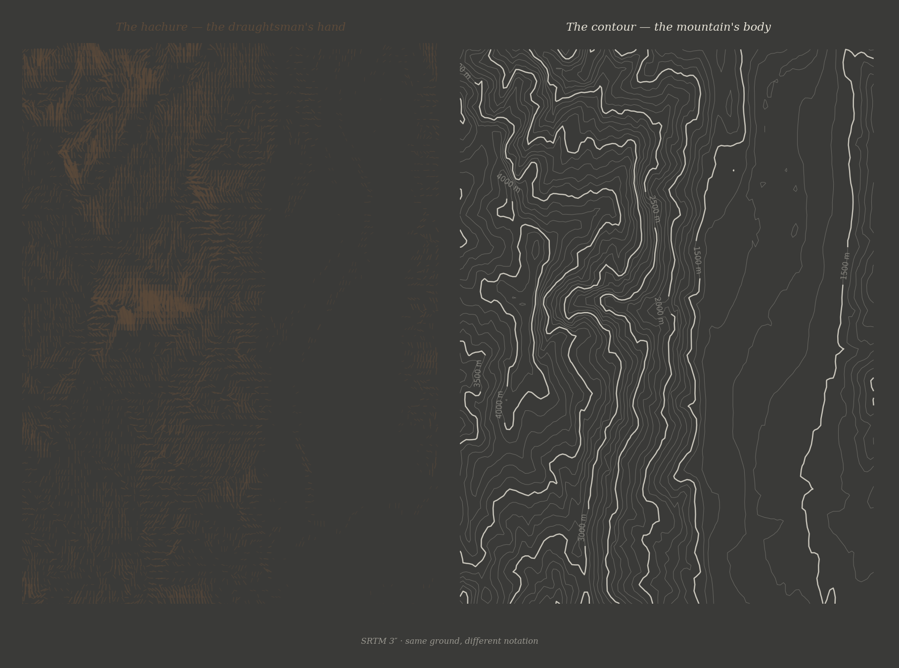
Same ground, different notation. The hachure carries the draughtsman’s hand. The contour carries the mountain’s body.
VI. The Hachure and the Contour
On the last evening, the Thread Walker asked the woman about the older methods. She had seen hachure maps in archives — the Survey of India maps from the 1860s, where the mountains were rendered in thousands of tiny strokes drawn by hand, each stroke in the direction of steepest descent, each stroke’s thickness proportional to the angle of the slope.
The hachures are beautiful, the Thread Walker said. They show the shape of the land in a way that contour lines do not. When I look at a hachure map, I see mountains. When I look at a contour map, I see numbers.
The hachures are art, the woman said. The contours are measurement. The hachure tells you what the land looks like. The contour tells you what the land is. The hachure is drawn by someone who stood on the ridge and looked at the slope and rendered what they saw. The contour is drawn by someone who measured the height at two points and connected them with a line. The hachure carries the draughtsman’s hand. The contour carries only the ground.
She paused.
But here is what I learned today, she said. When I used the contour — the measured shape — to make a picture, the picture had qualities I did not put there. The asymmetry. The drainage. The shadow on the eastern wall. These are not things I added to the picture. They are things the ground added. The contour does not carry the draughtsman’s hand. It carries the mountain’s body. And the mountain’s body is more interesting than the draughtsman’s hand.
The Thread Walker thought about the petroglyphs below. Ten thousand years of human marks on rock — the ibex, the stupas, the writing systems, the merchants’ prayers. All of them records of passage, records of seeing, records of someone standing at the gorge and making a mark to say: I was here, I saw this, I understood something of what I saw.
And then the satellite, passing overhead, making no mark at all — only a number, a height, a measurement. No intention. No composition. No understanding. Only: the ground is this high at this point.
But from those numbers, the gorge emerged. Not a picture of a gorge. Not a concept of a gorge. This gorge. This asymmetry. This drainage. This light.
She wrote:
The petroglyphs are ten thousand years of human seeing — each mark placed by a hand that chose where to strike. The survey is a machine’s passing — each number recorded by an instrument that did not choose and did not see. But the survey, composed, produces the gorge. Not an impression of the gorge. Not an interpretation. The gorge.
The carving says: I saw the ibex. The survey says: the ground is twelve hundred and thirteen metres above the sea. The carving is richer. The survey is truer. Neither is complete. The ibex lives in neither — it lives on the cliff, where it has always lived, indifferent to both the chisel and the satellite.
But if I wanted to show someone who had never been here what this gorge looks like — not what gorges in general look like, but what this one is — I would not send them a painting. I would send them the contour. The contour does not imagine. It remembers. And what it remembers is not what someone saw but what the ground was. The difference is the difference between testimony and evidence. Both are needed. But only one of them survives the witness.
A Human-Machine Collaboration (mu2tau + Claude). The Shuttle Radar Topography Mission (SRTM), flown on the Space Shuttle Endeavour in February 2000, measured the elevation of roughly eighty percent of the Earth’s land surface at three arc-second intervals (approximately ninety metres). The Thalpan petroglyph terraces lie at approximately 35.62°N, 74.60°E, at an elevation of 1,213 metres, where the Indus gorge achieves its deepest incision — the river drops to its lowest point between the summit of Nanga Parbat (8,125 m) and the gorge floor, a vertical relief of nearly seven thousand metres in twenty-one kilometres of horizontal distance. The profound asymmetry of the gorge at Thalpan — the Kohistan island arc wall climbing to 4,300 m in five kilometres east-northeast while the Indian plate wall reaches only 1,800 m to the west-southwest — is a consequence of the Western Himalayan Syntaxis, where the Indian plate buckles around the Nanga Parbat massif. The hachure technique was standard in British Survey of India maps through the late nineteenth century. Nicolaas Cruquius’s bathymetric chart of the Merwede (1728) is generally credited as the first use of contour-like isolines, though the technique was not widely adopted for terrestrial cartography until the early nineteenth century. The painter’s machine, the contour’s picture, and the ibex on the cliff are all real. Only the gorge is permanent.